Cataphracts Design Diary #2
Cataphracts commanders: there is no actionable intelligence in this post. Read on.
Since my first design diary entry, quite a few people have reached out to me asking about how to run their own. It’s really exciting! It’s very gratifying to see so many people excited and interested in running their own games based on my silly little wargame. That in mind, I thought this time I’d focus more on my development process, and explain a bit how I made the stuff that turned into the game that now is Cataphracts.
I wrote the rules that became Cataphract in more or less a daze, a flurry of ideas and development without much pause. I don’t necessarily recommend this—I stalled out hard on other work—but these kinds of game design benders can, in some circumstances, prove rewarding. I encourage you to tweak and modify these rules for your own campaign.
As I wrote the rules, I began work on the map and the broader campaign. I can’t share my detailed map or campaign files here (because my commanders read these posts), so instead I’ll just work through a small example, a vertical slice of a larger campaign.
First: choose a setting, a time and place to pattern your campaign on. In general, I recommend the “historical setting with serial numbers filed off” approach. It gives your players recognizable elements to work with, but frees you from the research necessary for a historical campaign, and allows you to scrub off some of the ickier parts of the history. I’m going to stick with the same one I use for my game—an Eastern Mediterranean / Black Sea type of place in the high-to-late middle ages, 13th–14th centuries, right around the Fourth or Fifth Crusade—because I’ve already done a fair bit of reading about this era and it’s pretty familiar. You should choose a period and area of history that interests you! One of the perks of premodern settings is that a lot of the basic technology of warfare is broadly similar, so these rules should scale relatively cleanly from the Parthians to the Safavids.
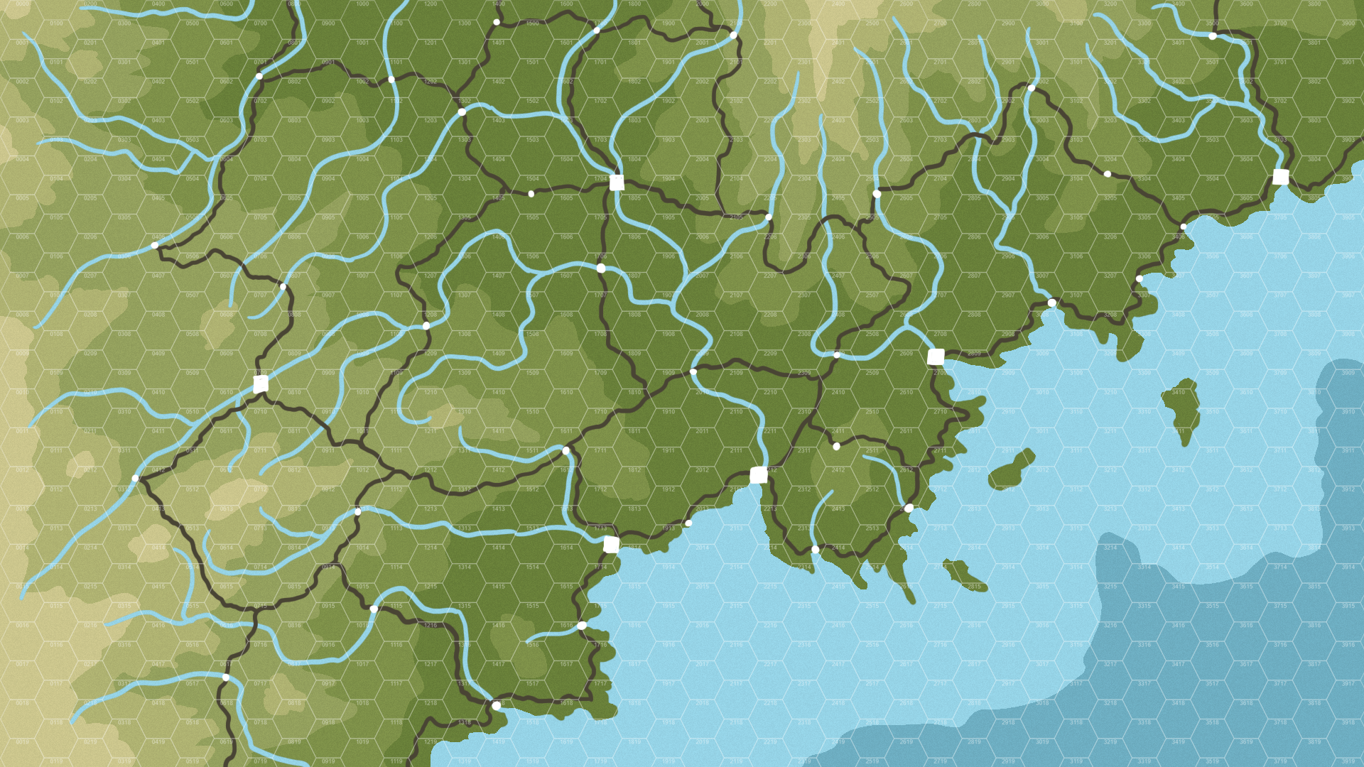
Let’s start with the map. My original Cataphracts map came from my friend Jason Ripplinger (they had a spare topographical map from a few years back they made for fun, since they’re that kind of guy), but you can honestly use almost any map, it doesn’t really matter—just make sure the map you choose includes rivers. Here’s one I made earlier.
 Blank topographic map
Afterwards, chuck a hex grid over it—I just print one off on hexgridgenerator. The hex grid matters mostly in terms of scale: my normal Cataphracts map is about 50 hexes (flat-topped) by 60 hexes, but roughly 40% of those are in water. We’re opting smaller for this demo map, and it’s wider than it is tall, so I’m setting it at about 40 hexes wide by about 20 tall (ish. I’m not measuring all that carefully). At 6 miles a hex, that puts this at something in the ballpark of 200 miles east-west and 100 miles north-south.
 With a hex grid
Next comes cities and towns (not yet fortresses). There’s no one formula for determining where humans build their settlements, but in general low, wet, flat land is easiest for farming, rivers and coasts offer access to trade, and distance provides a measure of safety and control. I would tentatively recommend only a handful of cities (1–2 per faction), but plenty of small towns.
Remember that, like a lot of maps, the measurement of space is often more critical and applicable as the measurement of time. Armies march two hexes a day, three at a forced pace; two towns fifty miles apart take four days to travel between, or three at a forced pace (forced-march cavalry only take a day and a half or so). Remember, too, how fast messengers travel—at about 8 hexes per day, a messenger could leave one of those towns in the morning and reach the other by evening. The map you draw strongly influences the flow of the campaign, and the complexities of maneuvering troops—distance becomes time, and time becomes information lag. The further commanders are apart, the harder it is to coordinate.
Here’s what we’ve got:
 Cities are squares, towns circles
You can see I’m not sticking to my own guidelines totally, because neither do people. Even ancient cities were built in unusual places, and well, cities in strange places are more fun. But generally the trend holds: the lowlands and coasts are thickly settled, the hills and mountains prove thinner.
Now, the roads. Roads connect settlements, and want to stay on level terrain. On topographic maps, they often loosely trace elevation gradients. Also, bridges are far more common in settlements than they are just out in the countryside, so keep your bridges confined mostly to settlements.
Armies almost always march on the road. As Devereaux describes, while maps often look like a big flat expanse of open land, they’re really more akin to a web of connections and pathways with walls or empty space between. (If you’re an RPG nerd, this is a hexcrawl, but in reality most armies end up treating it more like a pointcrawl.) Commanders will spend quite a bit of time figuring out how to best get from A to B, and the roads form the bulk of the setting, the playing field, with which they must contend. Those two towns fifty miles apart as the crow flies can end up far further if the road between them wends and winds.
Here’s our map with the roads.
 Roads!
As with most things on this map, there’s probably a more-historical way to fill these roads in, but what we’ve got here feels good enough. It’s got some roads that feel very efficient and logical and some that feel sort of odd and arbitrary. All settlements are connected to somewhere else, but there are sometimes gaps between major settlements’ connections.
Next: fortresses! Think like a commander, or a jealous and fearful king: where are the enemies going to march from? Where do you need to stick a castle to keep watch? We haven’t started drawing faction lines yet (though perhaps you’re already starting to guess where they’ll fall), but historical territory lines often shift, and fortresses designed to keep one foe out often end up repurposed against another.
Generally, this means crossroads, chokepoints, and positions that allow you to see a long ways. Sometimes, two fortresses end up getting built pretty close to one another—one to watch the other—even if they later end up on the same side.
You want a lot of fortresses. At least as many as cities and towns combined, if not significantly more. Even a small army garrisoned in a fortress can cause a ton of trouble for passing armies: settlements are the goal, fortresses are the obstacles. (If you study the history, there should probably be even more.)
Here’s our map with fortresses added:
 In theory, any single point could be the site of a decisive battle
You can see they sit at high points, choke points, and other key locations—prime real estate for commanders looking to force their opponents into a prolonged and costly campaign.
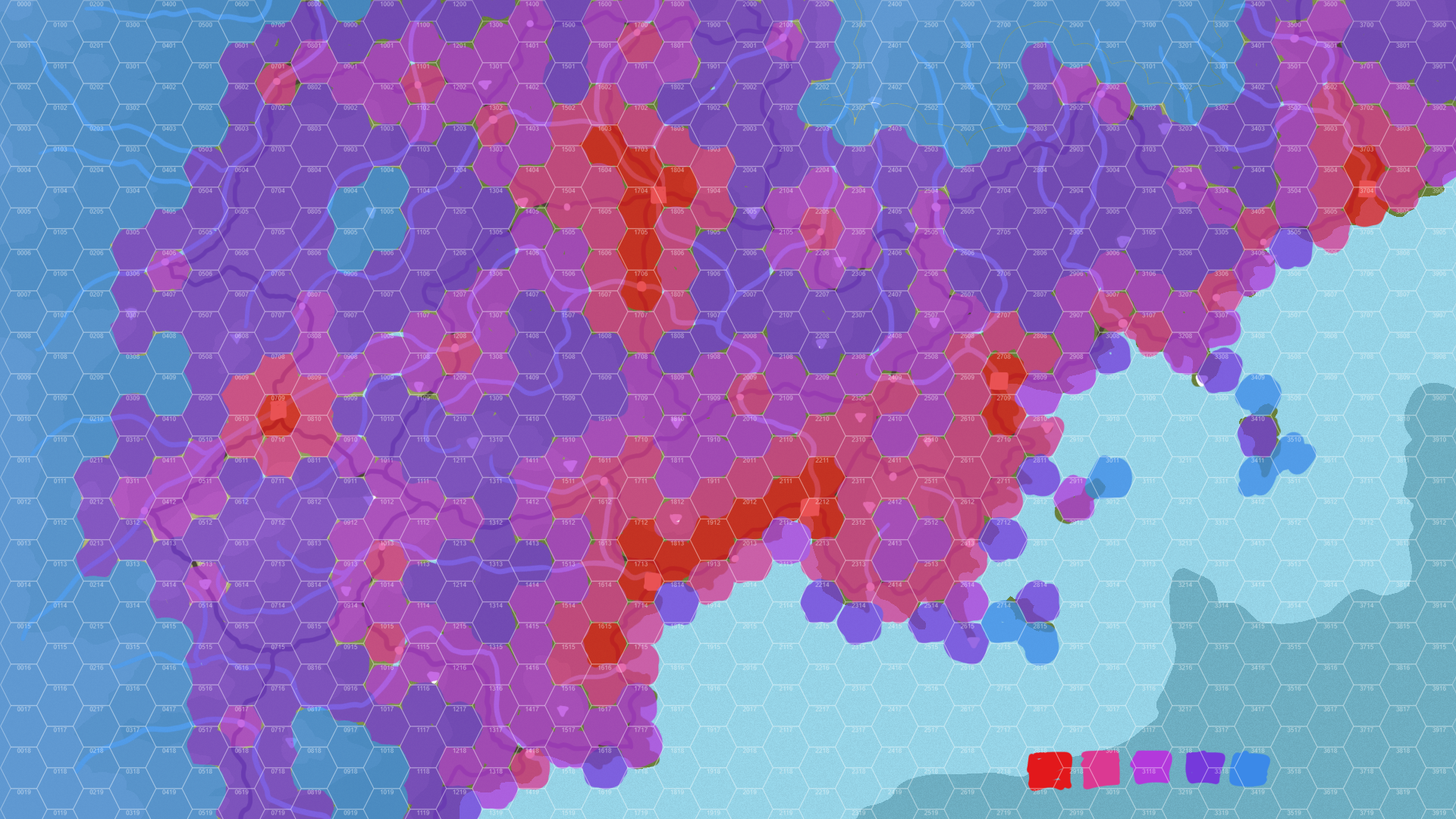
Right now, the map is more or less done in terms of topography, roads, and strongholds. There are two things left to do: settlement level and faction turf. Settlement level is effectively just a measure of population, or perhaps population and wealth put together. (If you’re a Crusader Kings nerd, consider that development level increases supply limits—we’re rolling both into one number here, but it’s the same idea.)
For settlement scores, I stick to 20-point increments, ranging from 100 (100 persons per square mile, quite densely settled) to 20 (20 persons per square mile, quite thin). If you’re into the deep verisimilitudinous worldbuilding, these settlement scores plug nicely into donjon’s Medieval Demographics Calculator.
I don’t have an official way to map settlement scores. Regions around cities should be quite dense with outlying suburbs, mountainous hinterlands should be very thin, and settlements follow rivers and roads. Otherwise it’s more or less a matter of eyeballing it.
Here’s our same map with settlement scores:
 Probably should’ve picked a different shade of blue than the ocean lol
You can see how the settlements follow relatively reliable metrics: dense along the big coastal port cities and rich valley towns, thinner as you get deeper into the wilds, and then quite empty way up into the mountains.
While I don’t show my players this map of settlement scores, wise commanders quickly learn to intuit where to find more and less population. Because settlement levels determine how many supplies an army can forage at once, this information can swing the tide of a campaign: foraging around a city can support an army for weeks or even months, while foraging in the outer wilds rarely lasts for more than week or two (depending on the size of the army and so on, naturally). Armies march on their stomachs, and campaigns live and die based on their ability to keep the troops fed.
Now, faction lines! Since this is a smaller map for a smaller game, I’m going to add just three factions, rather than the full five I have in my current Cataphracts game. With six cities, that gives each faction two cities, a pretty reasonable number.
In general, I encourage you to draw weirder faction lines than you might expect. While historical states and polities were almost always contiguous, drawing unusual lines encourages your players to get funkier with their movements and diplomacy.
Here’s what I’ve got:
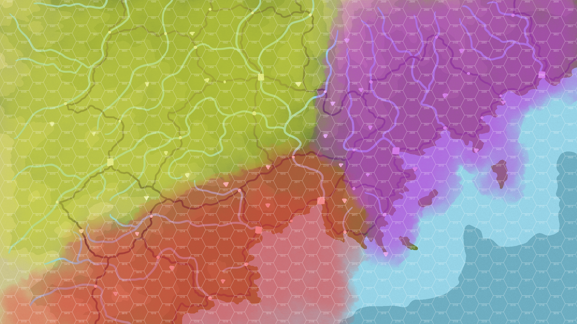 I would say Purple probably has the best position, but also likely the smallest starting army
Not terribly abnormal, but it does put each faction in a position where they need to start making decisions quickly about where and how they want to march. Once commanders commit, the flow of the game will get pulled to one region or another and things will get spicy fast.
If this were a map we were using for an active game, now would be the time for two rather tedious tasks: naming all of these strongholds, then doing the math to count up how many soldiers each faction starts with. I’m not going to do that here, since it’s kind of a pain, but that’s the next step.
(Eagle-eyed readers will notice that I’m skipping a possible step that gets mentioned in the core rules: regions. While I drew region lines onto my original map, I’ve quickly found they don’t actually matter, and are extremely fiddly to communicate to players. I plan to edit them out when I update the rules—in the meantime, you can just substitute anytime regions are mentioned with “hexes closer to a chosen stronghold than any other,” with priority going to larger strongholds.)
In terms of starting detachment types—how many cavalry, heavy detachments, wagons, and skirmishers—I mostly just eyeballed it. Strongholds (and thus factions) that seem richer, with more cities and denser population and an older history, got more heavy detachments; factions with more wilderness and hinterlands got more skirmishers and non-heavy cavalry.
I would highly recommend you start each faction with all available soldiers raised, skipping over the weeks and months it takes to levy all the troops and get them organized. Start each faction lead with all their soldiers in one place in one big block, ready to go.
At this point, you might be saying “Sam! These factions don’t seem very equal? Doesn’t this give one side an unfair advantage?” To which my answer is… yes, basically. Historically speaking, wars fought between equals are quite uncommon, especially perfect equals. You can do some work to even the lines out (factions with more troops get fewer heavies, etc.), but in general the factions are likely going to be uneven. Besides, being the bigger faction isn’t necessarily an advantage: it means more borders to defend, more soldiers to feed, and more commanders to organize. In my Cataphracts game, how many troops a factions started with has had effectively zero observable effect on both a faction’s success on campaign or their players’ enjoyment.
At some point in this process, you’ll also need to draw a player-facing, somewhat-inaccurate diegetic map (it’s the main image in my first post). Mine includes the names of all cities and towns, but not fortresses; its dimensions are close, but not perfect.
Now, let’s talk about player materials.
Each commander gets three documents: a faction sheet, a commander sheet, and an army sheet. A faction sheet is shared across all commanders in a faction, and includes a brief summary of the faction’s history and culture, their special rules, a quick overview of the other factions, and some tables of names and titles for commanders. Here’s an example:
High Duchy of Sarai-by-the-Sea
Three hundred years ago, Saint-King Mikhail the Mighty sailed to these shores, converted to the faith of the Orthodoxy, conquered the giants dwelling along the water, and proclaimed his own kingdom. Since then, the kingdom’s borders have shrunken somewhat (not least due to the Mikhailovichi fighting amongst themselves), but the lords of Sarai-by-the-Sea still trace their lineage back to the holy Saint-King.
As descendants of people from beyond the sea, the Saraians place great value in shipwrighting, warring along the coasts and rivers. From the others in Kyrenia, they learned horsemanship, poetry, and alchemy, offering their craft in ships and their deep knowledge of magic in exchange.
For the past seventy-five years, the High Duchy—as the kingdom became, in time—has been a subject of the Prince-Bishopric of the Ikosion, a large and prosperous theocracy along the southern coasts of Kyrenia. A proud people, the Saraians chafe beneath such subjugation, but scattered rebellions over the years have always failed.
Now, with the sudden and suspicious death of Grand Duke Vasily, the realm is thrown into chaos and fury. Why tolerate the Ikosenes’ rule? Why not rise once more, an independent kingdom for Saraians alone? Why not withhold the ancient territory set down by the Saint-King?
Fast, easy, lots of historical analogues to draw, not more than a few paragraphs. Brevity is essential here, since players must read and understand quite a bit before getting to play.
Here’s some sample special rules:
Saraian Special Rules and Detachments
Embarking and disembarking from ships takes half a day. Ships travel 6 miles per hour faster.Knight-Wardens: Knight-Wardens are heavy infantry. When defending a stronghold, they count quadruple for the purposes of determining numerical advantage.
Marines: Marines are skirmishers. An army of exclusively marines can undergo a forced march to travel along a river as if they were in a ship (at a regular pace), even without a ship.
Quick, breezy, and operational-level. It’s very easy to sucked into the minutiae of battle, but resist that urge: the juice of Cataphracts is not in the fine detail of tactics (go play any other wargame, if you like that), but rather the logistics of moving thousands of soldiers in synchrony.
I’m going to skip the tables of names and titles here along with other factions’ descriptions, since I assume you know how to make those—they’re much the same as they would be in any other tabletop RPG book.
That’s faction sheets, which all commanders in a faction have access to. A commander sheet looks something like this:
Grand Duke Zdravko Vasilyevich “the Tall” Razumihin
You were born to high nobility, first-born son of the duke, prepared for greatness from birth. Raised in the royal courts of Simurghzal, you’ve always been the fastest horseman, the canniest sailor, and the most handsome of men. Yes, your people were subjugated by the foreigners of the Prince-Bishopric of the Ikosion, but until this year that mattered little: you had your life, and they had theirs. That all changed when your father, Grand Duke Vasily the Harpist, died, poisoned at your banquet feast by Prince-Bishop Eulalia’s underhanded dogs. Now, your people howl for blood, and they look to you for leadership—and vengeance.
Stats
Age: 26 (October 11th, 1299)
Faith: Orthodox
Traits:
- Beloved. Your army gains +1 resting morale.
- Stubborn. Your army does not lose morale on defeat in battle.
Objectives
As determined by yourself, your family, and the Boyars’ Duma:
- Free the High Duchy from the rule of the Prince-Bishopric of the Ikosion.
- Reclaim the Saint-King’s Hawkfeather Crown, stored in Karkota’s reliquary vaults.
- If possible, kill Prince-Bishop Eulalia.
(This is a lead commander, so they start with a couple of bonus traits, a nickname, and standing objectives. Fresh subordinate commanders get only the normal amount of traits, receive their objectives from their superiors, and must earn their nicknames.)
Like the faction sheet, the goal here is to give players enough to understand who they are in brief, then get them playing fast. Don’t get bogged down in the nitty-gritty of history—the social complexities that emerge over the course of play are going to be far more exciting and compelling than any backstory.
Finally, the army sheet: a spreadsheet, with space to track supplies, morale, and detachments. These don’t translate neatly to markdown text, so I’m just going to link them: here’s a sample army sheet for Grand Duke Zdravko (probably after forking off some of his troops to subcommanders), and here’s a blank template army sheet for you to steal.
While this seems a lot, I realize, this is basically everything Cataphracts is on a material level. A mildly-complicated map, a bunch of documents and spreadsheets, and then a discord server with many individual channels. For a game that sometimes feels like it’s going to overwhelm me with its sheer size, it’s actually quite lightweight.
Just to recap:
- Take a map and layer hexes over it.
- Add rivers, cities & towns, roads, and fortresses.
- Paint on the settlement levels.
- Draw faction lines.
- Write up faction sheets. Name important locations.
- Do a bunch of arithmetic to figure out how many troops each faction gets. At some point in here, draw the diegetic map that all players see.
- Write the lead commanders’ sheets and draw up their army sheets.
- Find some players and put together a discord server.
Okay! That’s design diary entry #2. I hope that this sheds some light on my process, especially if you’re interested in running your own Cataphracts game. Next time, I think we’ll talk about the day-to-day running of the campaign itself from my side as referee. Thanks for reading.